35 East 100 North
Parowan, UT 84761
Phone: (435) 477-3331
Memorandum of Report
TO: Parowan City Council; Dr. Ronald M. Roth, MD, FACC; Jesse Smith; Little Salt Lake Chapter of the Sons of Utah Pioneers; all interested parties.
FROM: Steven D. Decker, Parowan City Council
DATE: September 23, 2010
RE: Location and Dimension of Parowan, Utah Fort(s)
Per the September 9, 2010 assignment of the City Council, I have undertaken the project of coalescing and reconciling the information given at that meeting regarding the old Parowan Fort or Forts (hereafter “Fort” or “Forts” as may apply). The methodology for this undertaking is thus:
1. Compile sufficient data regarding the placement, size, construction form and materials, timing of construction, and similar information of the Fort or Forts.
1. Compile information regardless of seeming conflicts in information.
1. Compile information based on “historic memory” of residents as necessary and applicable.
1. Document all compilations.
1. Consult with other researchers and knowledgeable persons regarding their research, research findings, and/or their informed decisions and opinions.
1. Sort, sift, and coalesce all compilations to arrive at the most reasonable conclusion as to the size and location of the Fort or Forts.
1. Complete this document by settling, as close as possible, the position of the Fort or Forts so far as is documentable and so far as the historical evidence brings me to a conclusion.
1. Community Bias: There will be those in the community who will recall traveling to a point just south of 100 North to remnants of the Fort wall. If this proves incorrect or in some way amended, the community may have difficulty accepting the change in tradition.
1. Personal Bias: Until reviewing Dr. Roth’s letter of September 1, I was unaware of a “Wooden Fort.” As a researcher I will have to look as objectively as possible at the evidence uncovered as it is documented and approach all such evidence objectively rather than as a “native son of Parowan.”
1. Documentation: “Tradition” may or may not be documentable. In addition, the first documented account of an historic activity may not be authenticated. This research will attempt to document references to the Fort or Forts and, if necessary, attempt to prioritize conflicting documentation.
1. Possible conflict between local histories, historians, and tradition and Dr. Roth’s research. Such conflicts often result in some sort of scholarly or traditional “turf” that becomes a matter of defense rather than objectivity.
Assistant LDS Church Historian, Andrew Jensen, wrote, “In the summer of 1854 the people of Parowan enclosed the old fort[1], which was 56 rods square, with a wall enclosing 112 rods square. The wall was to be 12 feet high and 6 feet thick at the bottom and 2 ½ feet at the top. By the 7th of November it was built all around, although not every place to its full height.
In the fall of 1854 a new flouring mill erected by George A. Smith and John C. L. Smith was completed; it was built within the fort walls. Just below the mill were Elijah Elmer’s cabinet shop and Calvin C. Pendleton’s machine shop” (74).
As Jensen documents, the above assertion is extrapolated from the Deseret News, 4 Jan. 1855: “When we arrived[2] there we found the people almost universally engaged at their city wall….I should judge they had enclosed half a mile square[3]…six feet thick at the bottom, and eight feet high all around, and intended to be built four feet higher next season….” The assertion that the wall will be completed “next season” is important and will be addressed more fully below.
The Deseret News further reported, “The new flouring mill of Messrs. Geo. A. Smith and John Calvin Smith, is…within the walls in the highest part of town[4]….Just below this mill[5] are E. Elmer’s cabinet, and C. C. Pendleton’s machine shops….”
Luella Dalton records that, “The Fort was fifty six rods square, divided into ninety-two lots, each two rods wide and four rods deep. A street four rods wide separated the lots from the public corral, which was in the center and occupied ten acres of ground. In the southeast corner of the corral, a four rod square was reserved for the Liberty Pole. In the southeast corner of the Fort, a four rod square was reserved for building a log council house (33).” Dalton places the “building…a little north of where Alvin Benson’s home (Elmer Lowe’s) now stands.” She reports the size of the council house at 22×44 [Seegmiller sets the size at 22 x 45], small by today’s standards but perhaps the pioneers needed less personal space because it was “large enough to hold the whole colony….”(34-35).
In the northwest corner of the Fort a four rod square was reserved for a bastion to command the Fort. There were two big double gates in the center of the walls on the east and on the west. The wall when completed was twelve feet high, seven feet thick at the base, and about three feet at the top (33-34).”
This final statement: “The wall when completed was twelve feet high, seven feet thick at the base, and about three feet at the top” seems to begin the confusion. It is the roughly the same dimension of the wall described in Jensen’s history. It seems Dalton might be confusing the wall of the original Fort with that of the 1854 Fort. The question arises: With “eighty men [having] commenced to build a road up the canyon, so as to get logs for building homes and some to saw into lumber” by January 21, 1851, only eight days after arrival (Dalton, 32), would they have built an adobe or mud wall with frozen earth or would they have utilized the abundance of logs? Yet, the frozen earth would have to have been excavated for the “setting” of the poles. Further, if the mud or adobe wall had surrounded the fort Dalton described, the measurements Dalton gives are, of necessity (and, I think strangely), internal measurements of the enclosure. Otherwise, the wall would have encroached into peoples allotments.
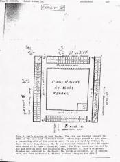
The smaller Fort is called Fort Louisa in several documents. This account seems to conform to John D. Lee’s attached drawing.
Dr. Ross’s September 1, 2010 letter indicates the presence of a vertical-log fort: “In the early 1850s the Fort was actually a 56-rod square vertical log-based wooden wall.” This assertion seems to be confirmed by the Deseret News as 1851 drew to a close: “The people of this colony [Parowan] are progressing as usual, going forward to picket in the Fort according the instructions from the Presidency.”
Some have suggested that a lot two rods wide by four rods deep (33’ x 66’) is insufficient for a home, garden, and fruit trees as Dalton suggests, but if one uses the Meeks Cabin (400 West near the pond), 484 square feet, a 2,178 square foot lot may, indeed, be sufficient. Surely if emergency accommodations of only 968 square feet were erected with the intention of housing the entire community in an emergency, a 484 square foot come on a 2×4 rod lot would seem spacious.
The 1,711 square foot[6] Jesse N. Smith home, built in 1856, seems more problematic but, based on surveys provided by Ironridge Civil Solutions, Inc. (civil engineering and land surveying) the lots inside the larger 1854 Fort were re-surveyed to be deeper but, it appears, to retain the original width – thus allowing more depth for gardens, stock corrals, and orchards.
Of course, the implication of the Meeks and Smith home examples is that we cannot apply current living standards or zoning requirements to a previous era.
Conclusions:
1. There is adequate evidence for two Forts, 1851 and 1854.
1. Rough calculation using Google Earth would indicate the 1851, 56 square rod fort to have included an area just larger than the town square ranging about 100 feet past the midpoint of the pavement on Center Street, 100 West, 100 South, and Main Street. Projected diagonally, this area would include the old Lowe home in the 1851 Fort, just as Dalton suggests.
1. Using the same sort of projection as described in #2, above, the corner markers of the 1854 Fort would be projected very near the Jess Askeroth home, the Gale Stolk home (perhaps even beyond the markers near these two homes), the Willie Topham home (near which there is a marker stating that the property was inside the Fort), and the west side of the old Rambouillet Barn.
1. Importantly, the claim that portions of the adobe wall ran through or near the rear yard of the old Jay and Doris Benson home is consistent with the approximate measurement. (Yup, hundreds of school children over decades saw a remnant of the wall).
1. The adobe wall was not the “original” 1851 Fort wall as may have been indicated, but was the remnant of the 1854 Fort wall.
1. Dr. Roth’s letter indicates his desire to mark the adobe wall. The City should look to the expanded parameters he suggests.
1. Google Earth, as expressed herein, is an insufficient indicator and the actual corner markers should be located by experienced surveyors. Google Earth is used, herein, as an indicator only.
1. Inasmuch as the literal southwest corner of the adobe Fort may be problematic for the erecting of a replica, the city and Dr. Roth may look to the “power plant” property (Dr. Roth’s stated preference) or the city park as alternative properties for replica placement.
My estimated measurements are taken from the approximate center of the Rock Church. In fact, Mormon tradition was that the southeast corner stone was laid first (“Ensign”). This, if this happened here, may slightly adjust actual survey if the southeast corner of the church is the center point of the old Forts. I have neither found nor sought documentation for this possibility.
Resources:
Dalton, Luella Adams. History of Iron County Mission Parowan, Utah. Print.
Jensen, Andrew [Compiler]. History of Parowan Ward. Provo, UT: Brigham Young University, 1955. Print.
“President Hinckley and the Nauvoo Temple.” Ensign Jul 2002: n. pag. Web. 15 Sep 2010.
Roth, Ron M. [Personal Correspondence] “To Mayor Don Landes and the Parowan City Council.” 01 Sep 2010. Print.
Scovil, Lucuis N. “Trip to Parowan, Iron County.” Utah Digital Newspapers. University of Utah, n.d. Web. 14 Sep 2010.
Smith, John L. “Local Correspondence.” Utah Digital Newspapers. University of Utah, n.d. Web. 15 Sep 2010. .
[1] Suggests that the 1854 Fort is the “new” fort.
[2] Extrapolation suggests about November 17th.
[3] The writer “judges” the wall to be one-half mile square. While his judgment is off, it seems to indicate substantial size. Remember, this is the same writer who reports the “new” Fort.
[4] Assuming current elevations are consistent with elevations at the time this was written, the “highest part of town” would have been the southeast corner of the Fort.
[5] If “below” refers to elevation it is reasonable to assume that these building were west, north, or northwest of the Smith/Smith flour mill.
[6] Information regarding square footage of Meeks and Smith homes was provided by Valorie Topham, Parowan City Recorder, from property insurance documentation.